


Looking for an interesting day road trip from Toronto?
A friend had suggested a road trip to the Ranney Gorge Suspension Bridge in the autumn, and as it is an easy drive from Toronto, I went to check it out.
The Ranney Gorge Suspension Bridge and nearby Ferris Provincial Park turned out to be all I expected, and you can use this helpful guide for your visit.
The Ranney Gorge Suspension Bridge makes for a great autumn hike, so in early October, we set off on the 2-hour drive from Toronto to Campbellford.
Ranney Suspension Bridge

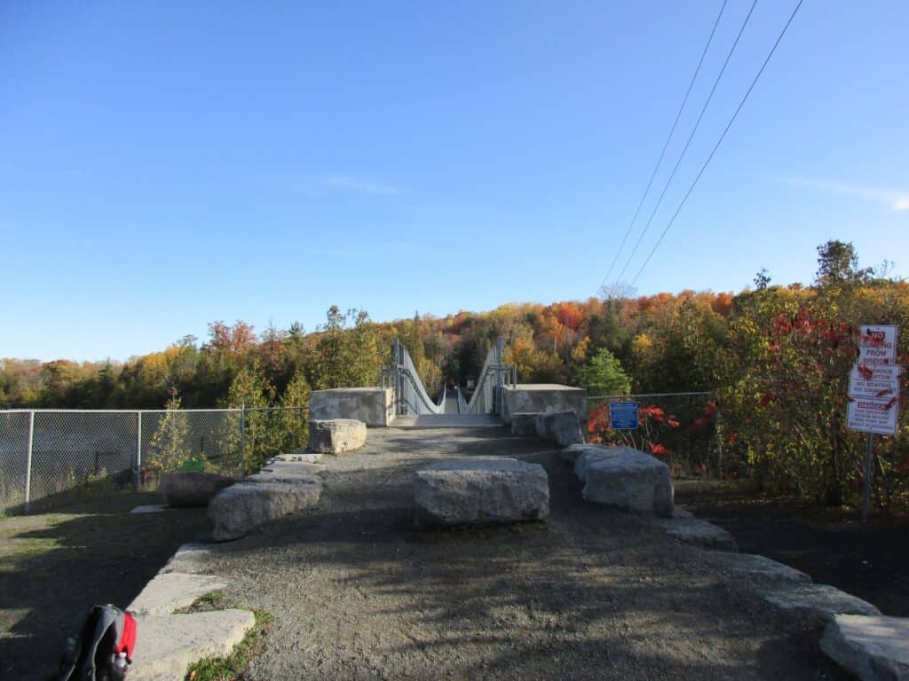
We parked by the locks on the Trent River and, following the signs,s walked past the Ontario Hydro plant to the entry point for the bridge, an easy walking distance. Adjoining Ferris Provincial Park on the far side of the river, with campsites and a number of hiking trails, is the only pedestrian bridge to the park.
The 300-foot-long (91 meters) Suspension Bridge Campbellford is not the longest in southern Ontario, as the 420-foot Collingwood Suspension Bridge by the Scenic Caves is longer. The suspension bridge in Toronto crosses the Rouge River along Sewells Road. The Eagle Canyon Suspension Bridge is the longest, at 600 feet (182 meters) is twice the length and Canada’s longest.
However, the Ranney Suspension Bridge, also known as the Campbellford Suspension Bridge, over the Trent River with an elevated view of the river and falls in the distance, is worth the trip; it may be Ontario’s most scenic suspension bridge. The open metalworks of the bridge help with the panoramic views.
We walked across the Trent Canal, passing the hydro plant until reaching the picturesque Suspension Bridge. Upstream, we could see a set of waterfalls, while downstream was the wide Trent River with the beautiful autumn colours on the trees lining the banks.
It is part of the Trans-Canada Trail, the longest recreational trail in the world, and is breathtaking any time of year.
Ferris Provincial Park Trails
All these routes may also be found on AllTrails, which has reviews and detailed maps.
1. River Gorge Trail

Distance: 3.5 km loop
Difficulty: Easy
Location: Ferris Provincial Park
We started off to the right, following the yellow blazes on the River Gorge Trail, an easy hike on a 3.5 km trail. It started off heading downstream along the Trent River, providing excellent views as you walk along the river’s edge. Along the walk with interpretive signage, you pass the old Ferris Quarry before arriving at a picnic area, known as the sheep wash.
On the return, the loop has a plaque describing the unique stone fences (some with steps to cross) and some which have been rebuilt and passes through some meadows.
2. Ranney Falls Trail

Distance: 2.3 km
Elevation Gain: 40 meters
Difficulty: Easy
Location: Ferris Provincial Park

The River Gorge Trail brought us back to the Suspension Bridge, so we headed off in the opposite direction again, along an easy river trail until arriving at Ranney Falls, where there is the Ranney Falls Lookout, very scenic, and you can view the strong currents as they flow over the rocks. The entire trail is a short 1 km ending at a picnic area and parking lot.
3. Drumlin Trail System
Distance: 6.2 km for Drumlin System or 9.8 km for Ferris Park Loop
Elevation Gain: 306 meters
Difficulty: Moderate hike with a few hills to climb
Location: Ferris Provincial Park, Campbellford

The Drumlin Trail System are 3 interconnecting moderate looped trails with the blue being 1.2 km, white 2.5 km, and red 2.5 km. We decided to hike the longest route around each which first had us on a bit of an ascent in a mature mixed forest with picturesque views in a number of places. Along the way, we passed some seasonal creeks that have developed into 2 elongated hills called drumlins. We also passed the Ferris family’s sugar houses.
The far side of the red trail was in an open grassy area with a county highway and the edges of Campbellford visible before looping back to the start.
Fun Fact: The cost of the bridge was $465,115, and it weighs 75,000 pounds.
4. Ferris Park plus Trent River Route

Distance: 7.9 km
Elevation Gain: 146 meters
Difficulty: Easy

Includes existing trails in Ferris Provincial Park, plus a short walk across the suspension bridge to check out the locks along the Trent-Severn waterway. Dogs on leash are permitted. Good to snowshoe or cross-country ski in winter.
Ferris Provincial Park
One end of the Ranney Suspension Bridge is located in Ferris Provincial Park, and there is the trail network described above. In addition, there are picnic shelters, tables, and washrooms. There is an entrance fee if arriving on County Road 8, with Ferris Park open May-Oct.
Make a weekend of it by camping in one of the 2 campgrounds. If you have kids, consider the Bedrock Loop, as it is close to a playground, and it also offers some sites with electrical outlets. The Valleyview Loop is on top of the Drumlin and has better views. There are many special events at Ferris Provincial Park that you may wish to consider when booking.
Visiting the Campbellford Area
Campbellford, a small town of 3400 people, is located just to the north, and if you have time, you may wish to check out the area. It’s a good way to cap off your visit.
- Trent-Waterway Locks 11 and 12 – to bypass Rannie Falls, two locks were built on the site of a former timber slide. If visiting from mid-May to October each year, you might want to stop and view the boats going through the locks and read the signs explaining how it all works.
- Dooher’s Bakery – located in the heart of Campbellford, this shop is amazing. I enjoyed a Black Forest cupcake to die for.
- World’s finest chocolate store – outlet store at 157 Cockburn Street. We went there for many Laura Secord chocolate seconds.
- Empire Cheese – just along County Road 8 from the entrance to Ferris Provincial Park, they had a good selection. A long history in the area dates from the 1870s.
How to get to Ranney Gorge Suspension Bridge
By car – We took Highway 401 east from Toronto to Brighton and Highway 30 north toward Campbellford, a distance of about 170 km.
Once we reached the town, we crossed the Trent River on Bridge Street (County Road 8) and did an immediate right turn heading along the river on Saskatoon Avenue and then right on Trent Drive over a bridge onto an island
Parking:
A second way is to drive right into Campbellford, take a right on County Road 8 and follow it to the main entrance of Ferris Provincial Park.
Walking or cycling the Rotary Trail – a 6 km route from downtown Campbellford to Locks 11 & 12.
FAQs: Ranney Gorge Suspension Bridge
How long is the Ranney Gorge Suspension Bridge?
The Ranney Gorge Suspension Bridge, part of the Trans Canada Trail, is 91 meters or 300 feet long and sits about 9 meters or 30 feet above the Trent River. It is located on the south end of Campbellford, right beside locks 11 & 12 of the Trent Canal. The longest suspension bridge in Ontario is at Scenic Caves in Collingwood.
Where do you park for the Ranney Suspension Bridge?
Go to 15 Trent Drive, Campbellford (east side of the river), and park by locks 11 & 12. Walk past the hydro plant to the bridge. A second way is to drive to Ferris Provincial Park, 474 County Road 8, Campbellford, and to Ferris Park, although there is a fee for entry.
Where is Ranney Falls?
Just north of the Suspension Bridge in Campbellford, walk along the 1 km Ranney Falls Trail, where you can view both the falls and bridge. Part of a loop trail in Ferris Provincial Park, which includes a picnic area.
Best time to view the Ranney Gorge Suspension Bridge?
A good time is in the autumn, late September or early October, when the colours make the area special. However, the bridge is open year-round.
Where is Ranney Gorge Suspension Bridge?
Ranney Gorge is in Northumberland County and the town of Campbellford, about 170 km east of Toronto and just north of Brighton. Take Hwy 401 East and then Hwy 30 North to reach Campbellford, where you cross the Trent-Severn Waterway and go right on Trent Drive.
How high is the Ranney Gorge Suspension Bridge?
It is about 30 feet (9 meters) above the Trent-Severn Waterway.
Looking for more information on Ontario Provincial Parks?
If you are considering visiting some of the other provincial parks in Ontario, read one of our posts on other parks:
- On the shores of Georgian Bay, visit Killbear Provincial Park
- Known for its amazing hiking trails, consider the trails of Lake Superior Provincial Park
- North of Ferris Provincial Park is Algonquin with plenty of hiking trails
- Hiking closer to Toronto in Mono Cliffs Provincial Park
- Ontario Provincial Parks close to Toronto – all within an easy drive of the city
What to bring on your Ranney Gorge Hike
Wrap-up: Ranney Gorge Suspension Bridge
Along a very scenic section of the Trent River is the Ranney Gorge Suspension Bridge with a set of falls just upstream, a great destination worth an autumn visit.


