


One of the best things about living in Toronto is how easy it is to escape into nature. Within an hour or two of the city, I can be hiking to waterfalls, standing on the edge of the Niagara Escarpment, exploring peaceful forests, or taking in spectacular views over Georgian Bay. Whenever I need a break from the traffic and busy streets, I don’t have to travel far to find an outdoor adventure.
Over the years, I’ve discovered that some of Ontario’s best hiking trails are surprisingly close to Toronto. Whether I’m walking through Rouge National Urban Park, chasing waterfalls at Smokey Hollow, admiring the cliffs at Mono Cliffs, or enjoying the fall colours in Algonquin Provincial Park, each trail offers something unique.
Some of these best hiking trails near Toronto are perfect for families and beginner hikers, while others are more challenging and reward you with dramatic lookouts and a greater sense of wilderness, and I like that I often see wildlife.
In this guide, I’m sharing my favourite hiking trails near Toronto, ranging from easy walks to more challenging adventures!
Quick Guide: Best Hikes Near Toronto at a Glance
| Trail | Distance from Toronto | Difficulty | Highlights |
|---|
| Forks of the Credit | 1 hr | Moderate | Waterfalls |
| Mono Cliffs | 1.5 hrs | Moderate | Cliffs & forests |
| Dundas Peak | 1 hr | Moderate | Escarpment views |
| Rattlesnake Point | 1 hr | Easy-Moderate | Lookouts |
| Rouge National Urban Park | 30 min | Easy | Urban nature |
| Algonquin Park | 3 hrs | Moderate | Wilderness |
Interactive Map of Hiking Trails Near Toronto
1. Rouge National Urban Park
The distance from Toronto is 30 minutes (borders the city)

Rouge National Urban Park is an area of forests, meadows, fields, wetland, and a beach. Located on the eastern side of Toronto, it stretches from Lake Ontario all the way to Stouffville.
The plan is to have one continuous trail for the entire distance, but that is still under construction. Meanwhile, in the southern end of the park, you can enjoy the Vista, Mast and Orchard Trails. I often go further into the park, walking the Monarch Trail, which has a variety of scenery.
There are excellent birdwatching opportunities, and I often see wildlife, usually coyotes and deer.
Check out my post on the hiking trails at Rouge National Urban Park. TTC can reach the park for Rouge Beach (Lawrence Bus), Zoo Road for several trails or a short drive for the other hikes.
Note: In 2026, trail construction will take place at Rouge Beach and also at Zoo Road for a Visitor Centre.
2. Forks of the Credit Provincial Park
The distance is about 1 hour north of Toronto

An easy drive north of the city, Forks of the Credit Provincial Park, offers hiking along sections of the Trans Canada Trail, the Bruce Trail and additional park trails.
Many people head for the metal stairs, taking you down to the Forks of the Credit itself with several bridges over the river. Further along the river is a former power plant and Cataract Falls.
However, the park has more to offer, and you can continue along the Credit River for valley views before hiking up one of several trails to the top of the hill, where you walk over rolling countryside with several small ponds.
Reservations are required from the Ontario Parks website. The park is very busy due to the exceptional fall colours, especially on weekends.
3. Mono Cliffs Provincial Park
Distance is 1.5 hours north of Toronto

Mono Cliffs Provincial Park is one of my favourites for hiking. From the main parking lot, you can follow the trail to a T-Junction. From there, go to the right, and you have several options.
You will be walking in a valley with steep rocky cliffs on both sides and birds of prey flying overhead. There are several small ponds along the way, and you can walk gradually up a hill with great views. You can even see the CN Tower in the distance.
Continue, and if you may pass McCarron Lake, Jacob’s Ladder and a Viewing Platform. Depending on your route, you can also expect boardwalks, cliff-edge viewpoints, spring wildflowers, and old apple orchards. This is especially scenic in the autumn, and you can see lots of other visitors. Read my post for more about the Mono Cliffs trails. You will require reservations from Ontario Parks to visit.
4. Dundas Peak & Tews Falls
Distance is 1 hour west of Toronto in the Hamilton area

Spencer Gorge Conservation Area consists of Webster Falls, Tew Falls, and Dundas Peak. Reservations are no longer required, and parking is now on a first-come, first-served basis. I find Webster Falls more of a family-oriented scenic picnic area.
So I head nearby to Tew Falls and Dundas Peak, which requires an uphill hike with viewing platforms along the way. At the top, you have panoramic escarpment and Dundas Valley views. The Bruce Trail goes through the area, and you can make a longer hike if you wish.
5. Rattlesnake Point Conservation Area
Distance is 1 hour west of Toronto, just off Highway 401

Head west along Highway 401 to the Milton area to visit Rattlesnake Point Conservation Area. There are several short family-friendly trails, picnic tables, and scenic escarpment viewpoints from the cliffs, which are especially good in the fall for autumn colour.
I always follow the Nassagaweya Trail, part of the Bruce Trail, down the valley and up the other side to Crawford Lake, just over 14 km return.
6. Crawford Lake Conservation Area
Distance is 1 hour west of Toronto

Continue a little further along Highway 401 to Guelph Line, drive through Campbellville, and the entrance is on your left.
After parking, head to the Visitor Centre where there are washrooms and a small exhibit area. Then follow the trail passing a series of wooden animal carvings. Follow the boardwalk around the entire meromictic lake (it’s not that long), which is deeper than its surface area.
Then I go to the Iroquoian Village reconstruction, where you will find several Longhouses and usually a staff member to talk about life there. One of the Long houses has an extensive exhibit area, and there is a garden from that time as well.
There are several easy hiking trails in the park, some with great viewpoints. However, I always follow the Bruce Trail (Nassagaweya Trail) into the valley and up the other side to Rattlesnake Point Conservation Area.
Open all year, I recommend reservations at Crawford Lake Conservation Area, although they are not required.
7. Hilton Falls Conservation Area
Distance is 1 hour west of Toronto, just off Highway 401

Most visitors to Hilton Falls Conservation Area just follow the wide main park trail to the falls for a view and then return. A pleasant, wide trail, family-friendly.
However, I usually follow the Bruce Trail and some other park trails, which are a little more rugged. When I arrive at the falls, how much water is going over the falls depends on the time of year. This park is particularly popular in the fall.
8. Mount Nemo Conservation Area
Distance is 1 hour west of Toronto, just off the QEW

Mount Nemo Conservation Area has amazing views from the cliffs, picnic spots and birdwatching opportunities. Reservations are recommended but not required.
This park is more about the views with a short trail, so personally, I tend to head to other nearby parks, such as Smokey Hollow or Rattlesnake Point, but it still makes a nice day trip.
9. Cheltenham Badlands and the Bruce Trail
The distance from Toronto is 1 hour north

The Cheltenham Badlands are very unique in Ontario, with the distinctive red-coloured rolling hills and receive a lot of visitors. Do make reservations with the Ontario Heritage Trust. Whether you are a photographer or not, you will want to take a lot of pictures.
There are two trails in the park, one with a boardwalk, going to a viewing platform. The Bruce Trail also crosses the Cheltenham Badlands.
It can get very busy in the fall and on weekends, so visit early or midweek to avoid the crowds. It is also cheaper to visit on weekdays. Although not a major hiking destination, it is worth a visit because it is so different.
10. Albion Hills Conservation Park
Distance is 45 minutes north of Toronto

Albion Hills Conservation Area is a very popular park for camping, hiking, mountain biking and in the winter, snowshoeing or cross-country skiing. Gently rolling with forested sections and small ponds.
The park has 9 hiking trails of varied length, the longest being the 12.4 km Outer Loop. I generally walk the Humber Heritage Trail, which starts in the park and runs all the way to the nearby town of Bolton, following the course of the Humber River.
11. Short Hills Provincial Park
The distance is 1.5 hours from Toronto to the St. Catharines area

There are 7 easy hiking trails in Short Hills Provincial Park, including the Bruce Trail, which follows the Niagara Escarpment. Decrew waterfalls and others are highlights of this park. I usually combine a visit here with Balls Falls.
12. Smokey Hollow Waterfall Trail
The distance from Toronto is 1 hour west in Waterdown

I have been hiking the Smokey Hollow Bruce Trail for years, and it is one of my favourites. It is great for families, and I see a lot of dogs along the trail as well.
There is a very small parking lot (free) near Waterdown and a viewing platform to see the historic stone ruins and waterfalls. But this is not the best part. Take the wooden staircase along the Bruce Trail down to Grindstone Creek to view the falls from a different angle.
Then follow the creek along the trail and down stairs in a heavily wooded area. On weekends, expect a lot of people, particularly in the fall, as the colours are awesome. While not usual, I have even seen huge fish attempting to navigate upstream in the fall.
13. Algonquin Provincial Park
Distance is 3 hours north of Toronto, plus wherever you go on Hwy 60

Algonquin Provincial Park is open all year and is an easy 3-hour drive from the city for snowshoeing and cross-country skiing, plus great hiking for all levels.
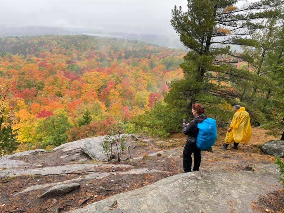
Once you arrive, most visitors head for the short Lookout Trail, with an uphill climb for sweeping vistas of the fall colours. Warning that during autumn weekends, there is limited space and it sells out, with police and parks staff checking permits. I arrive early and leave by the time the crowds arrive.
I headed for the nearby Beaver Pond Trail while some of my friends tackled the more challenging Track & Tower Trail. Read my post on the Algonquin Park hiking trails for a review of your options.
14. Bruce Trail at Lion’s Head
Distance is 3.5 hours north of Toronto

Lions Head is on the Bruce Peninsula with sweeping Georgian Bay views from the dramatic cliffs. It is very popular, so parking was a problem on my arrival.
The Lion’s Head Lookout Trail is a moderate 7.2 km trail with the Bruce Trail crossing the area. I recommend overnighting in the area, as it is a long drive.
15. Bruce Peninsula National Park – The Grotto
Distance is 4 hours north of Toronto

People flock to the Grotto located in Bruce Peninsula National Park near Tobermory. You need to make reservations to obtain a time slot for entry, and then there is a short hike to the Georgian Bay shoreline to view the sea caves and turquoise waters. Expect to see lots of other people.
Because you will want to overnight anyway, what I do is book a campsite at the Cyprus Lake Campground, then I can go to the Grotto or any of the other hiking trails whenever I want, no waiting. You can also hike the Bruce Trail, as well as the shoreline.
Note: In 2026, the Canada Strong Pass provides discounted camping and free admission to all Canadian National Parks from June 19 to September 7.
16. Balls Falls Conservation Area
About 1.5 hours from Toronto in the Niagara Region

You are not really going to Balls Falls Conservation Area for the hiking, although there are two short trails. What you will find are 2 waterfalls (limited water over falls in summer), an extensive historic village, lovely picnic area along the river. The Bruce Trail goes through the park.
Excellent fall colours and a festival with large crowds, which I discovered by accident, but glad that I went. Very family-friendly.
17. Dundas Valley Conservation Area
Distance is 1 hour from Toronto, near Hamilton

The Dundas Valley Conservation Area is located near Hamilton, with over 40 km of trails of all levels through the Carolinian Forest. It’s in the Hamilton area, so there will be waterfalls, and there are connections with the Bruce Trail.
Best Hiking Trails by Interest
Best Waterfall Hikes

- Smokey Hollow, near Waterdown (Burlington)
- Hilton Falls, near Milton, just off Hwy 401
- Webster’s Falls & Tew Falls, near Hamilton
- Forks of the Credit, near Toronto
- Balls Falls Conservation Area & historic village in the Niagara area
Best Family-Friendly Hikes

- Crawford Lake with a boardwalk around the lake, carvings, and a First Nations Village
- Rouge National Urban Park with hikes for all levels on the edge of Toronto
- Balls Falls with two easy hikes and the Historic Village
- Dundas Valley Conservation Area with lots of trails
- Rattlesnake Point has excellent viewpoints from the escarpment
- Cheltenham Badlands, because it is such a different experience
Best Fall Colour Hikes
- Algonquin Provincial Park
- Forks of the Credit
- Mono Cliffs
- Dundas Peak
- Cheltenham Badlands
Best Scenic Lookouts

- Lion’s Head
- Mount Nemo
- Rattlesnake Point
- Mono Cliffs
- Algonquin Park, Track & Tower Trail
What to Pack for Hiking Near Toronto
- Hiking shoes or boots
- Water bottle
- Bug spray
- Layers for changing weather
- Trail snacks
- Downloaded maps
Best Time to Go Hiking Near Toronto

Spring to see waterfalls at full strength and wildflowers. Aim from mid-May to mid-June before the bugs come out in force.
Summer has longer days and lush forests, but can be extremely hot and humid. In late June and early July, there may be a lot of insects.
Fall is the best time for hiking in Ontario to see the spectacular autumn colours, and the weather is still pleasant.
Winter offers snowshoeing in many parks and frozen waterfalls.
FAQs: Best Hiking Trails Near Toronto
What is the best hike near Toronto?
Forks of the Credit, Mono Cliffs, and Rattlesnake Point are consistently ranked among the best hikes near Toronto.
Where can I hike within an hour of Toronto?
Lots of places, such as Rouge National Urban Park, Rattlesnake Point, Hilton Falls, and Crawford Lake, are all easy day trips.
What are the best waterfall hikes near Toronto?
Smokey Hollow, Webster’s Falls, Tews Falls, Hilton Falls, and Cataract Falls at Forks of the Credit are excellent choices.
What is the best fall hiking destination near Toronto?
Algonquin Provincial Park, Mono Cliffs, and Forks of the Credit are among Ontario’s top fall colour destinations.
Final Thoughts: Best Hiking Trails Near Toronto
Ontario has so many hiking trails within easy reach of Toronto for various levels, and the opportunity to see wildlife.
The long-distance Bruce Trail running from Queenston Heights near Niagara to Tobermory on Georgian Bay offers plenty of opportunities for shorter hikes.
Expect to see waterfalls, wildlife, varied terrain, and scenic vistas, whichever hike you are planning.


